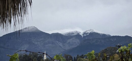
Snow has officially fallen across several regions of South Africa this morning as a powerful winter storm moves across the country, confirming forecasts of one of the most widespread snow events in years.
The heaviest snow is still to come — with over 50cm expected in places like Barkly East and Afri Ski by Monday.
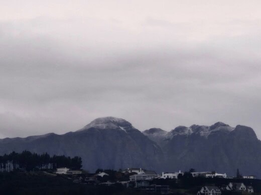
Vox Weather’s Michelle du Plessis said the system will intensify as it develops into a cut-off low, dragging freezing levels lower and setting the stage for heavy snow over mountain ranges, including the Drakensberg, Southern Lesotho, and parts of KwaZulu-Natal, where the deepest accumulations are expected.
With social media already buzzing among snow hunters eager to witness the event, forecasters warn that travel conditions could become hazardous, especially on mountain passes and rural roads.
Authorities urge South Africans to prepare for widespread frost, strong winds, and icy conditions on Sunday and into next week, and to closely monitor updates as forecasts continue to evolve.
Here is where you will find snow:
In the Western Cape:
- Matroosberg,
- Cederberg,
- Swartberg
In the Northern Cape:
- Nuweveld and Roggeveld mountain
- including the town of Sutherland,
- the Great Karoo
The high-lying areas in the Cape provinces:
- around Fraserburg,
- Loxton,
- Murraysburg,
- Richmond,
- Noupoort,
- Colesberg,
- Burgersdorp,
- Aliwal North,
- Molteno and surroundings.
Lesotho could experience snow depths exceeding 50cm on Monday, particularly around Afri Ski, and in the Eastern Cape may expect between 50cm of snow over the southern Drakensberg and nearby towns. Including Barkly East.
A mixture of snow/ ice rain and sleet is now possible over southern and eastern Free State:
- Bethlehem,
- Warden,
- Heilbron,
- Reitz,
- Memel,
- Reddersburg,
- Trompsburg and surrounding towns.
It includes north-eastern parts of the Northern Cape, around Postmasburg and Kuruman.
Meanwhile, the South African Weather Service has issued a Yellow Level 1 warning for damaging coastal winds from Saldanha Bay to Cape Agulhas, and icy road conditions are expected across several interior districts, especially around Beaufort West.
With snowfall already likely over Lesotho and nearby areas by Sunday and heavier falls predicted through next week, South Africans are advised to monitor updates closely and prepare for travel disruptions, icy roads, and sudden temperature drops.
Also read: Snow expected in Gauteng next week
Do you have more information about the story?
Please send us an email to bennittb@rekord.co.za or phone us on 083 625 4114.
For free breaking and community news, visit Rekord’s websites: Rekord East
For more news and interesting articles, like Rekord on Facebook, follow us on Twitter or Instagram or TikTok.
At Caxton, we employ humans to generate daily fresh news, not AI intervention. Happy reading!
Corné van Zyl
www.citizen.co.za
