Using a collection of five survey methods, the team of six hikers collected over 14 500 records of plastic pollution. Front left to back: Liz Bazin, Chris Leggatt, Mandy Pelser, Ariadne Van Zandbergen, Jonathon Britton. (Photo supplied)
“Come have a look at this,” Jonathan Britton called above the wind and the rumble as the surf pulled back from the sloped pebble beach.
He was standing next to a postbox-red, sit-on-top-of plastic kayak, its bow buckled and split, with goose barnacles sprouting from the surface.
He pointed out a sticker of an adventure company based at Storms River Mouth in the beverage holder. Chris Leggatt, knowing the owner, sent him a message asking when the kayak had been lost. Minutes later, the response came through, “Washed out to sea on the 10th of August.”
In less than 10 weeks, the kayak had drifted more than 400km to wash up west of Suiderstrand at the southernmost tip of Africa.
Britton is one of six members of the 2024 Strandloper Project hike that took place over 12 days in October.
The project started as a desire to learn more of the effect of recreational fishing along the southern Cape coastline and has, since 2018, grown into a series of coastal expeditions surveying the density and distribution of ocean plastic waste.
The day we spotted the kayak was the eleventh day of our coastal research expedition and we had already collected more than 13 000 records of washed-up ocean plastic waste ranging from hard plastics — such as lids, sucker sticks, toothbrushes, buckets and crates — to soft plastic like shopping bags, dog poop bags and condoms.
There were plastic bottles, pieces of polystyrene and plastic cutlery. Some sandy bays had a slick of microplastics — broken down pieces from a multitude of plastic containers — and nurdles, the raw material used to manufacture every plastic item that we use on a daily basis.

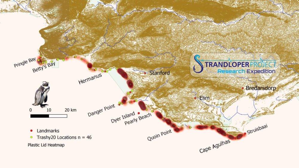
In 12 days, we had completed 228km of hiking along the shoreline from Pringle Bay to Struisbaai, documenting the plastic and fishing debris.
Using a bouquet of five survey methods to categorise types of plastics and determine their density and distribution along the shoreline, our objective was to determine the source of plastic pollution and where it flows into the ocean.
The range of items suggested that the bulk of plastic washing up on the beaches originates from urban settlements and that it flows into the ocean through municipal infrastructure and gets flushed from rivers during flood pulses.
The density, shape and size of items, driven by winds and currents, influence how far certain types of plastic drift and ultimately where it washes up. Along the section of shoreline hiked during this expedition, most of the plastic was recorded on the western facing shoreline, with lower densities recorded on the eastern facing sections.
During our 2022 expedition from Arniston to Hermanus, we recorded the highest density of monofilament of the four expeditions we had done at that stage.
Again, this year, this 228km section of the coastline ranks as the highest density of monofilament along 1 050km of coastline that we have surveyed between Pringle Bay and Cape Recife.
Snagging in kelp stipes (or stems), the lost recreational fishing tackle poses both an entanglement and ghost fishing threat to marine birds and fish respectively. In addition, as the monofilament disintegrates from UV exposure, it remains in the marine ecosystem as microplastics.
Some items that had drifted even further than the kayak were medical packaging and small packets of snacks, which had been released from containers lost at sea during a storm offshore of East London.
The packaging and snacks began washing up at Port Alfred on 9 September and along the Garden Route on 19 September. By the time that they started washing ashore near Pearly Beach in the second week of October, they had drifted more than 840km.
These specific items came from ships being rerouted around the Cape of Storms because of the conflict in the Middle East.
In addition to surveying plastic and fishing gear, we also use the opportunity to record marine fauna. A species we have collected valuable data on are the African black oystercatchers.
This year, we recorded 1 204, with a mean density of 5.3 birds/km. This is an increase of 6.4% on our 2021 expedition for the section of shoreline between Struisbaai and Grotto Beach.
To stem the flow of plastic into the ocean is going to take a modification in how we, both municipalities and society, manage our plastic waste.
For our future, we need a paradigm shift to use plastic waste as a resource and to commoditise the collection and upstream processes.
For more information, visit www.strandloperproject.org or email expedition leader Mark Dixon on [email protected]
Des Erasmus
mg.co.za
