
Thunderstorms and scattered showers are expected in some provinces, but partly cloudy conditions for the rest of SA. (rbkomar/Getty Images)
Thunderstorms and scattered showers are in store for at least four provinces, but according to the South African Weather Service, it will be partly cloudy and cool elsewhere in the country.
Impact-based warnings
A Yellow Level 1 warning has been issued for damaging winds over the north-western parts of KwaZulu-Natal.
Localised damage to settlements (formal and informal) and localised problems for high-sided vehicles on prone routes due to cross winds on exposed high-level roads/bridges is expected.
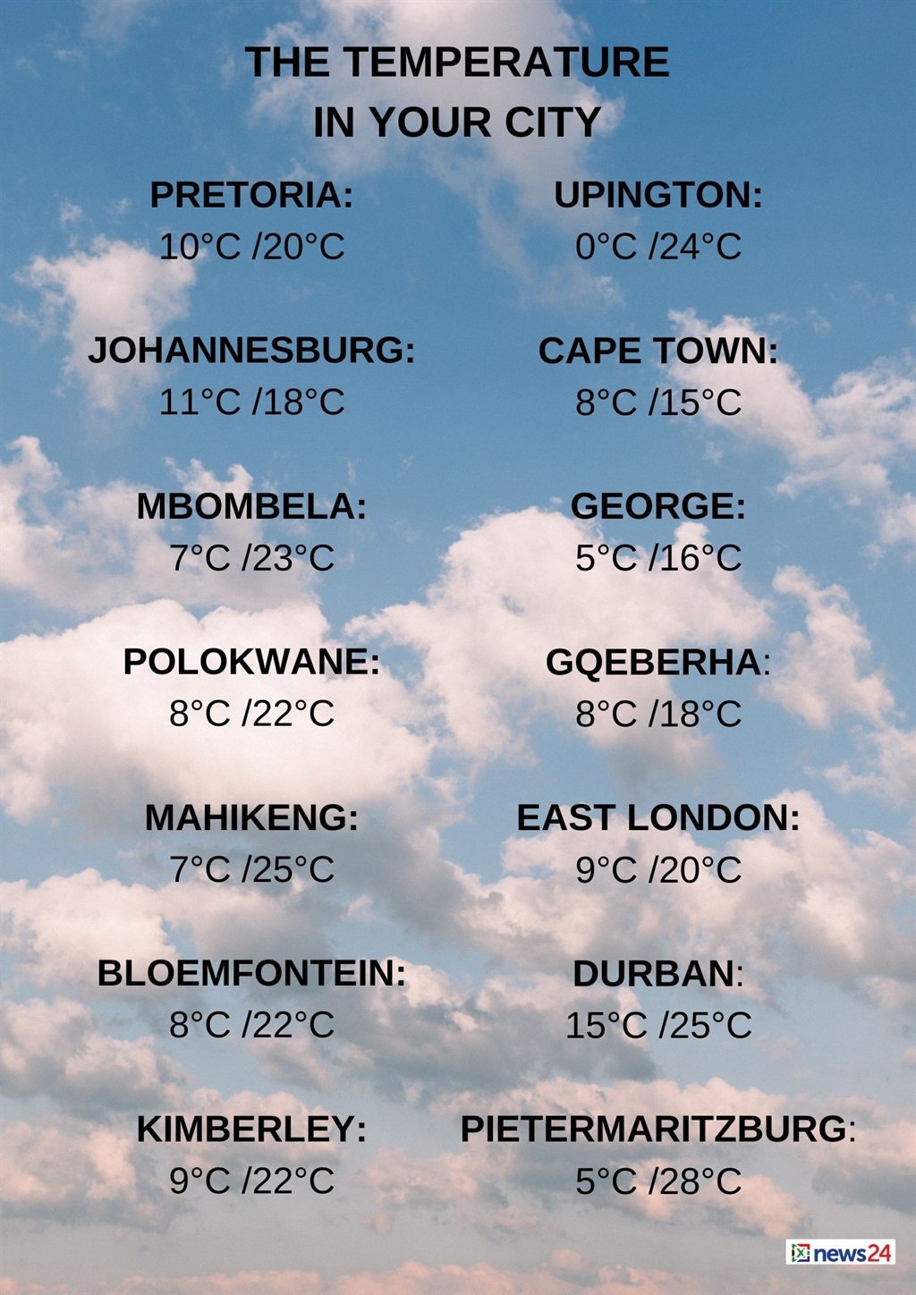
The weather in your region
Partly cloudy conditions are forecast in Gauteng, becoming fine and cool.
The expected UVB sunburn index is high.
Mpumalanga will be warm on the Lowveld, otherwise partly cloudy and cool temperatures are expected with morning fog in places on the Highveld.
It will become fine in the north by the afternoon.
Cloudy conditions are forecast for Limpopo’s east at first, otherwise partly cloudy and cool to warm temperatures with morning fog patches are expected in the north, becoming fine by the afternoon.
The North West can expect fine and cool to warm conditions.
Partly cloudy and cool temperatures are forecast for the Free State with isolated showers and thundershowers, except in the north.
As the weak upper air system exits the country, isolated to scattered thundershowers can still be expected over southern parts of KwaZulu Natal and northern parts of Eastern Cape. pic.twitter.com/BHXrpIwJfT
— SA Weather Service (@SAWeatherServic) August 1, 2024
The Northern Cape will be partly cloudy with isolated showers and thundershowers in the south-east at first, otherwise fine and cool temperatures are expected.
The wind along the coast will be fresh to strong south-easterly.
Partly cloudy conditions with morning fog are forecast for the south and west of the Western Cape.
Otherwise, fine and cool to cold temperatures are expected while it will remain partly cloudy during the afternoon.
The wind along the coast will be moderate to fresh north-westerly to westerly between Slangkop and Plettenberg Bay.
Otherwise, a moderate to fresh southerly to south-easterly, becoming a moderate northerly, is expected between Lambert’s Bay and Hout Bay from late morning.
The expected UVB sunburn index is low.
The western half of the Eastern Cape will be cloudy with isolated showers and thundershowers in the east at first.
Otherwise, partly cloudy and cool conditions are forecast, but it will be warm in places over the interior.
The wind along the coast will be light to moderate north-westerly at first, otherwise a moderate to fresh westerly wind is forecast.
Cloudy and cool conditions are expected in the eastern half of the province with scattered morning showers and thundershowers, becoming partly cloudy.
The wind along the coast will be light to moderate northerly along the wild coast at first, otherwise a moderate to fresh south-westerly wind is expected.
KwaZulu-Natal can expect partly cloudy and warm temperatures, but it will be cool in the south-west.
Isolated showers and thundershowers are expected, except in the north.
The wind along the coast will be moderate to fresh northerly to north-easterly, becoming southerly to south westerly from the south spreading to Cape St Lucia by evening.
The expected UVB sunburn index is high.
news24
www.news24.com
