Heavy rain, damaging wind and fires are expected over the weekend. (Busang Senne/News24)
Disruptive rain, damaging winds and high fire danger conditions are expected in several regions over the weekend, according to the South African Weather Service.
Impact-based warnings
An Orange Level 5 warning for disruptive rain, leading to flooding of roads and settlements, is expected over the City of Cape Town, Cape Winelands and the Theewaterskloof Municipality in the Western Cape.
A Yellow Level 4 warning for disruptive rain, leading to disruption of traffic flow, due to major roads being flooded and damage to property is expected over the West Coast, Langeberg, Overstrand and Cape Agulhas Municipalities in the Western Cape.
A Yellow Level 3 warning for damaging interior winds, leading to possible difficult driving conditions, especially over major routes, is expected over the southern high ground of Namakwa in the Northern Cape, the City of Cape Town, Cape Winelands, Overberg, Garden Route and Central Karoo in the Western Cape.
An Orange Level 6 warning for damaging wind and waves, leading to difficulty in navigation at sea, is expected between Cape Columbine and Cape Agulhas on Saturday morning, spreading to Alexander Bay and Plettenberg Bay by Saturday evening.
A Yellow Level 2 warning for damaging wind and waves, leading to difficulty in navigation at sea, is expected between Plettenberg Bay and Port Alfred from Saturday afternoon.
Fire danger warnings
Extremely high fire danger conditions are expected in places over the Dr Beyers Naude, Inxuba Yethemba, Sunday River Valley and Blue Crane Route municipalities in the Eastern Cape.
Advisories
A significant cold front is expected to affect the Western, Northern Cape and Eastern Cape from Saturday into Monday.
The public and small stock farmers are advised about the expected intermittent heavy downpours, snowfalls, very cold conditions, strong coastal and interior winds as well as very rough seas.
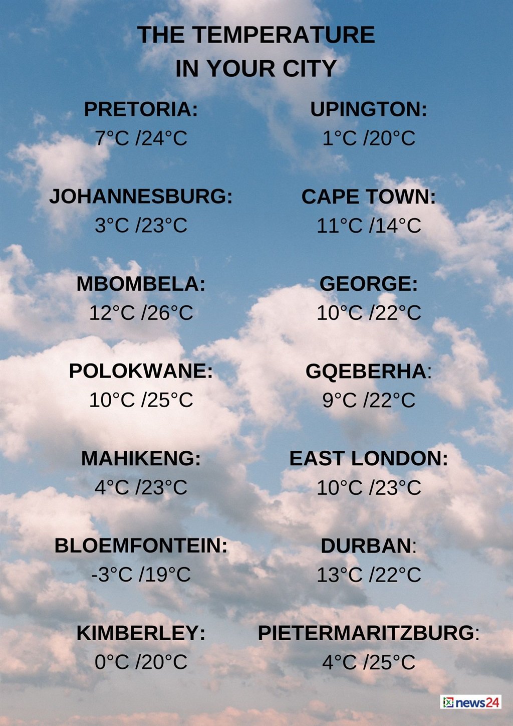
The weather in your region
Fine and cool temperatures are expected in Gauteng, but it will be warm in the north.
The expected UVB sunburn index is very high.
Mpumalanga will be fine and cool to warm.
Fine and warm conditions are forecast Limpopo, but it will hot in the extreme north.
The North West can expect fine and cool to warm temperatures.
Fine and cool conditions are forecast in the Free State.
Another cold front is expected to make landfall tomorrow bringing with it scattered to widespread showers and rain with strong winds and waves along the coast together with strong interior winds and possible brushes of snowfall over the high-lying areas ??????? pic.twitter.com/zoVzmqtrqZ
— SA Weather Service (@SAWeatherServic) July 26, 2024
The Northern Cape will have morning fog patches over the interior, but it will be cloudy to partly cloudy over the Western parts, with isolated showers and rain, spreading to the southern parts from the afternoon.
It will be fine and cold, but very cold in the southern parts, where snowfall is expected from the evening.
The wind along the coast will be a moderate to fresh northerly to north-westerly.
Windy and cloudy to partly cloudy conditions are expected in the Western Cape, but it will be cold to cool in the south-eastern parts and overcast over the south-western parts from the afternoon.
Isolated to scattered showers and rain are expected, but there will be widespread showers and rain over the extreme south-western parts.
Snowfall is expected over the high-lying areas from the evening.
The wind along the coast will be a moderate to fresh westerly to north-westerly, but strong to gale along the south-west coast, spreading to the west and south coast from the afternoon.
The expected UVB sunburn index is low.
MEDIA RELEASE: Cold snap to affect the Cape provinces from Saturday until Monday
(27 to 29 July 2024) due to an intense cold frontal system pic.twitter.com/81Y7pWxXbR— SA Weather Service (@SAWeatherServic) July 26, 2024
The western half of the Eastern Cape will be windy in places over the interior.
It will be fine and cool, becoming cloudy, with scattered showers and rain in the south-west in the evening.
The wind along the coast will be a light to moderate north-westerly, becoming a strong south-westerly from the west in the evening.
The eastern half of the province will be cloudy, with fog patches in places south of the escarpment at first.
It will be fine and cool, but windy in places over the interior.
The wind along the coast will be a light to moderate north-westerly, becoming north-easterly by midday, but light and variable at times south of Coffee Bay.
KwaZulu-Natal will be fine and cool, but warm over the north-eastern parts.
The wind along the coast will be a light to moderate southerly to south-westerly south of Durban until late morning.
A moderate to fresh northerly to north-easterly wind is forecast.
The expected UVB sunburn index is very high.
news24
www.news24.com
